ICAP2025


The PROSPECT international thematic network on archaeological prospection at Ghent University, along with its partners, is proud to present the 16th International Conference on Archaeological Prospection in Ghent (Belgium) from 15-20 September, 2025.

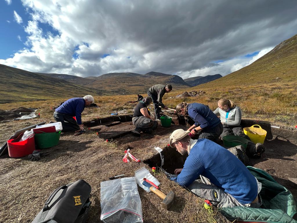
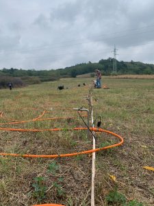
On behalf of the International Society for Archaeological Prospection (ISAP), the conference seeks to offer a platform for presenting and discussing the latest advancements and innovative research in archaeological prospection. It will encompass the full range of approaches for detecting, locating, and investigating buried cultural heritage.  These span non-invasive techniques such as near-surface geophysics and remote sensing, as well as invasive approaches including borehole survey and trial trenching, alongside the suite of associated methods focused on  data processing, visualization, and archaeological interpretation.

Get to know our local organizing committee & scientific committee.

Follow ISAP on Facebook, X or Linked-in to stay up to date with the latest news on ICA¨P2025.

Join the conversation with #ICAP2025 to network with experts and connect with other attendees!

Deadlines

Abstracts

  • Submission: 6/12/2024
  • Review: 20/2/2025
  • Revision: 20/4/2025
  • Notification of acceptance: 1/5/2025

Registration

  • Early-bird: 1/3/2025
  • Regular: 1/7/2025

Preliminary program

Monday 15 September

  • Workshop on archaeological prospection data processing using Open-Source software (limited number of places)
  • Evening: Welcome to Ghent in the Ghent city hall

Tuesday 16 September

  • Morning: Registration + Oral paper sessions
  • Afternoon: Oral paper sessions
  • Evening: Opening Reception at the Gravensteen castle

Wednesday 17 September

  • Morning: Oral paper sessions
  • Afternoon: Poster session
  • Evening: Conference dinner in Chaptre Hall St. Peter’s Abbey

Thursday 18 September

  • Morning: Oral paper sessions
  • Afternoon: Oral paper sessions
  • PROSPECT partner meeting

Friday 19 September

  • Morning: Oral paper sessions
  • Afternoon: Oral paper sessions
  • AGM ISAP

Saturday 20 September

  • (optional) Excursion to Bruges and the Zwin region

Sessions & Keynotes

Abstracts

Until the deadline, abstracts can be submitted for scientific poster or oral presentations (max. 15 minutes) that fit within our sessions.

Abstract formats:

  • Short abstract: 2 pages, 1 image (poster presentations).
  • Extended abstract: 4 pages, 3 images (oral and poster presentations).
  • All submissions for oral presentations require an extended abstract.
  • For poster submissions, authors can choose to submit either a short or extended abstract.

Submitted conference abstracts will receive two blind peer reviews, proposing revisions and will be published upon acceptance in a special open access issue in ArcheoSciences, revue d’Archéométrie by 15.09.2025.

A printed copy of the conference abstract can be ordered during registration.

Please make sure your abstract follows the author guidelines before submitting.

Abstract submission

Fees & Registration

To be confirmed.

Registration is not open yet

The conference qualifies as ‘verdiepende opleiding voor erkende archeologen’. Please, provide your recognition number during registration if you’re an archaeologist recognized by the Flemish heritage agency.

Locations

Conference location

Virginie Loveling Building (VAC Ghent)

Address: Koningin Maria Hendrikaplein 70, 9000 Ghent, Belgium (view map)

Opening reception

Address: Gravensteen, Sint-Veerleplein 11, 9000 Ghent, Belgium (view map)

Conference diner

Address: Sint-Pietersabdij, Sint-Pietersplein 9, 9000 Ghent, Belgium (view map)

Ghent

There are many reasons not to come to Ghent (with ICAP2025 not being one of them!).

Ghent is a captivating Belgian city that blends medieval charm with modern culture. Highlights include Gravensteen Castle, St. Bavo’s Cathedral, and its scenic canals and streets lined with historic buildings. Known for its vibrant arts scene, street art, and numerous museums, Ghent also offers a lively atmosphere fueled by its student population. With cozy cafes, bars, and restaurants, it’s an ideal destination for history enthusiasts, art lovers, and travelers seeking a rich cultural experience.

The most important information for visitors has been compiled on visit.gent.be.

Hotels

We have arranged a direct booking link for conference attendees with the Ghent-hotels non-profit, which arranges bookings without commission.

Hotel booking link is not active yet

How to get to Ghent?

Videos:

How to get around Ghent?

Ghent is very bike friendly and has affordable public transport.

Visa

Read all the information about the visa requirements for Belgium.

Social events & Excursion

Social events

Excursion

The medieval port of Bruges and the Zwin estuary were a dynamic landscape shaped for centuries by the interaction between nature and humans. The Zwin turned Bruges into an economic and cultural hub, with several thriving port settlements along its shores. However, after 1500, Bruges and its ports declined, leaving the medieval landscape as a remnant. The results of more than ten years of archaeological, historical, and geophysical research by Ghent University in Bruges and the surrounding area will be the guideline of the scientific excursion on 20/09/2025.

Instructions for presenters

For Poster Presentations

  • Poster Format: Prepare your poster in A0 size (841 mm x 1189 mm), in portrait orientation, and bring the printed version to the conference.
  • Materials Provided: We will supply the necessary materials to hang your poster.
  • Poster Setup: Please hang your poster as soon as you arrive. The posters will remain on display for the conference duration (Tuesday – Friday).
  • Poster Pitch: Prepare a concise 2-minute pitch to be presented during the plenary session. If you are unable to present it at the conference, a recorded video is required. Please practice your pitch to stay within the 2-minute limit, and feel free to use one slide (of your poster) if it helps illustrate your main points.
  • Poster Session: You are required to be present at your poster during the designated poster session on Wednesday afternoon.

For Oral Presentations

  • Presentation Format: Prepare your presentation as a PDF or in Microsoft PowerPoint format, and bring it on a USB drive.
  • Presentation Timing: Each presentation is allotted 15 minutes, followed by a 5-minute discussion. The session chair will signal you when 2 minutes remain in your presentation time.
  • Technical Setup: Please upload your presentation to the conference laptop during the break before your session (refer to the detailed program for timing), or, if you’re presenting in the first session, between 8:30 and 9:00 a.m., or the evening before.

Sponsors & Exhibitors

Academic Sponsors


Commercial sponsors

Are you interested in exhibiting  at ICAP 2025? Read more about sponsoring.

Contact

If you can’t find the information you’re looking for on our website, feel free to reach out to us via PROSPECT@UGent.be.

Workshop Report “The City Below the City” published on ArchéOrient Blog

We are pleased to announce that a report on the recent PROSPECT workshop titled The City Below the City – Archaeological and Geophysical Data to Meet Major Heritage Management Challenge is now available on the ArchéOrient Blog.

This workshop brought together experts from various fields to explore innovative approaches in heritage management, focusing on how to protect and study archaeological sites beneath modern urban landscapes.

The report highlights cutting-edge geophysical techniques, case studies, and collaborative strategies that emerged during the discussions. It provides valuable insights into how interdisciplinary approaches are shaping the future of urban archaeology and heritage conservation.

Visit the ArchéOrient Blog post to read the full report.


Workshop: The city below the city-archaeological and geophysical data to meet a major heritage management challenge

The UMR Archéorient (CNRS, University of Lyon 2), in collaboration with the PROSPECT International Thematic Network are excited to announce the upcoming scientific Workshop on Archaeological Prospection in Urban Environments, scheduled for April 3-4, 2024.

Focused on the interdisciplinary fields of archaeological prospection and heritage management in urban settings, this event promises to be an enriching and informative experience for researchers in archaeology and geophysics, urban archaeological heritage managers and archaeological prospection practitioners alike.

Event details

Dates

3-4 April 2024

Format

Hybrid: Live workshop with webcast

Target audience

  • archaeological and geophysical researchers
  • urban heritage managers
  • archaeological prospection practioners

Registration

via https://event.ugent.be/registration/citybelowcity

Program

Wednesday 3rd April 2024

9:00 Welcome coffee and reception of the participants
9:30 Workshop Introduction

Session 1: Archaeological Prospection and Data Management in Urban Environments

9:45 M.-L. Bassi (Directrice du patrimoine historique, UMR 6298 Artehis), Thomas Chenal (UMR 6298 Artehis) Besançon, a case of archaeological data management by its preventive archeology service
10:15 P. Belford (Heritage Innovation) Urban archaeology, data management and public heritage. some UK perspectives
10:45 Coffee break
11:15 J. Bouwmeester (Cultural Heritage Agency of the Netherlands) Modelling urban archaeology. Mapping expectations and disturbances in urban context in the Netherlands.
11:45 E. Hofmann, H. Tronchère-Cottet, E. Leroy (Service Archéologique de la Ville de Lyon) ALyAS (Archéologie Lyonnaise et Analyse Spatiale), a GIS for managing (geo)archaeological data for the city of Lyon.
12:15 M. Serlorenzi, A. D’Andrea, R. Montalbano, C. Rosa, P. Rosati, D. Sepio (Soprintendenza Speciale Archeologia) SITAR: a new approach for geomorphological reconstruction of ancient Rome through massive geoarchaeological data assessment
12:45-14:00 Lunch Break


Session 2: Case Studies of Archaeological Prospection using Geophysical Approaches in Urban Environments

14:00 D. de Ruijsscher, W. De Clercq (Ghent University) Combining geophysical data, invasive methods and archival research in reconstructing historic town topography. Some case-studies in the Belgian Zwin region (Belgium, The Netherlands)
14:30 J. Creighton (University of Reading), L. Verdonck (University of Cambridge), M. Milett (University of Cambridge) Reconstructing Roman York beneath the streets: legacy data and first GPR prospection results
15:00 B. Fores, G. Hulin et F.-X. Simon(INRAP) Urban Archaeological Prospection in Preventive Archaeology: Lessons and Prospects from Case Studies at INRAP
15.30 Coffee break
16:00 S. Kay (British School of Rome), S. Piro (Institute of Heritage Science-CNR), G. Morelli (Geostudi Astier), E. Pomar (British School of Rome) Urban investigations in the heart of the empire: Archaeological prospection in the Rome Transformed Project
16:30 M. Dabas (CNRS, AOROC), A. Tabbagh (Sorbonne université, METIS), S. Flageul (Sorbonne université, METIS), C. Schamper (Sorbonne université, METIS) Electrostatic surveys for archaeological prospection in urban environments: a review of 30 years of case studies
17:00-17:45 General Discussion

Thursday 4th April 2024

Session 3: Innovations in Geophysical Prospection of Urban Environments

9:00 S. Flageul (Sorbonne université, METIS), C. Schamper (Sorbonne université, METIS), M. Dabas (CNRS, AOROC), A. Tabbagh (Sorbonne université, METIS) Electrostatic surveys: principles and latest developments
9:30 L. Verdonck (University of Cambridge), J. Creighton (University of Reading), M. Millett (University of Cambridge) Recent trends and innovations in ground penetrating radar survey for urban environments
10:00 N. Papadopoulos, D. Oikonmou (Institute for Mediterranean Studies) Advancements and Innovations of electrical resistivity tomography in urbanized environments
10:30 Coffee Break
11:00 D. Boddice (University of Birmingham) Introducing cold atom gravity gradiometry: modelling its potential for urban archaeological prospection
11:30 T. Avgitas (IN2P3), C. Benech (CNRS, Archéorient), L. Brissaud, J.-C. Ianigro (IN2P3), Jacques Marteau (IN2P3), Benoit Tauzin (UCB LYON1) The novel use of muons for subsurface investigations
12:00 L. Bodet (Sorbonne Université, METIS), Q. Vitale(Éveha International, Archeorient)J. Cunha Teixeira (Sorbonne Université, METIS), A. Burzawa (Sorbonne Université, METIS), J. Thiesson (Sorbonne Université, METIS), M. Fondrillon (Service archéologique de Bourges Plus, CITERES), C. Benech (CNRS, Archéorient)
Surface wave seismics in urban prospection: seeking robust results in noisy environments
12:30 B. Tauzin (Université Lyon 1, LGL-TPE), J. Rodet (Université Lyon 1, LGL-TPE), S. Durand (Université Lyon 1, LGL-TPE), J. Marteau (Université Lyon 1, IN2P3), T. Avgitas (Université Lyon 1, IN2P3) Seismic survey with optic fiber: potential benefits in urban prospection
13:00-14:00 Lunch Break


In-person practical training workshop: Ground Penetrating Radar (GPR) data processing

14:30-18:00 T. Wunderlich (Kiel University) This (in-person) training workshop will demonstrate and teach the use of MultichannelGPR – A New MATLAB-Tool for the Processing of GPR Data.

Further info on the software in this publication. The code can be downloaded from GitHub here.

Basic knowledge of GPR data processing is advised.

While a Matlab installation is required on your personal computer (free trial here), no Matlab programming knowledge is necessary for this workshop.

Please note that registration is for this in-person training session on a first-registered, first-served basis, as spaces are limited to 25.

We encourage prompt registration to secure your spot.

For those attending the workshop in person but unable to secure a spot in the training session, there will be an opportunity for a guided site visit (no registration required).

Further information

Venue

Museum and archaeological site of Saint-Romain-en-Gal (Vienne, France)

 Location

Email

prospect@ugent.be

Webpage

https://www.prospect.ugent.be/workshop-city-below-the-city/

Organized by


Supported by


Exploring Geophysical Surveys and Archaeological Prospection at Waterloo: A Testimonial of a UGent Research Visit

We are delighted to share a testimonial from a Duncan Williams, who embarked on a research stay at Ghent University in the fall of 2021.

This endeavor was undertaken in the context of his PhD research, which is hosted by the Waterloo Uncovered project, Bournemouth University-dpt. of Archaeology & Anthropology and Ghent University-ORBit.

Magnetometer survey at Waterloo

“In the fall of 2021, I undertook a 2-month research stay at Ghent University in the framework of my PhD research, based at Bournemouth University. The goals were to conduct some initial fieldwork for my PhD, as well as to gain practical experience more generally with a range of geophysical survey methods and data processing workflows in collaboration with members of the PROSPECT network. Under the supervision of Dr. Philippe De Smedt, I was based at the ORBit (Spatial Soil Inventory Techniques) research group in the Department of Environment.


Despite the ongoing challenges of the COVID pandemic, the research stay was a definite success. Preliminary geophysical surveys were conducted at the battlefield of Waterloo (1815), which is the primary focus of my doctoral research aimed at elaborating prospection methods for identifying the elusive archaeological traces of pre-modern battles.


I also participated in several other projects being undertaken by the research group in other areas of Belgium, involving large-area electromagnetic, magnetometry and ground-penetrating radar surveys. Another highlight was my participation in the installation of a monitoring station for in-situ recording of seasonably-varying physical properties of interest as part of a novel survey optimization project undertaken by the research group.


The hospitality and expertise of PROSPECT staff members at Ghent University combined with the impressive suite of geophysical equipment housed at the ORBit research group made for an extremely rewarding and productive research stay.”

If you’re keen to explore a research stay at a PROSPECT member, please don’t hesitate to contact us via prospect@ugent.be.

PROSPECT Members Unearth Mesolithic Secrets, Featured on BBC Radio Scotland

PROSPECT researchers and students from University College Dublin and Ghent University, as well as from University of Stavanger,  recently embarked on a captivating archaeological expedition investigating the Mesolithic in Mar Lodge (Cairngorm Mountains, Scotland). Their excavation revealed a small artefact scatter and its hidden secrets. Alongside the discovery of multiple lithic artefacts, soil samples collected during the dig potentially hold its magnetic signals.

This collaboration is nestled within the newly approved MesoMag project, dedicated to unraveling the magnetic properties of Mesolithic traces in dryland environments.

Journalist Helen Needham visited the site, and her illuminating report is now featured on BBC Radio Scotland’s “Scotland Outdoors” podcast. Tune in to uncover the enigmatic details of this intriguing research.

Archaeological excavation at Glen Dee

Geoarchaeological reconstruction of Holocene coastal landscapes along the North Sea

Introduction

The PROSPECT international thematic network, the High Tide – Low Tide CRA at Ghent University and the Bruges archaeological service RAAKVLAK are hosting an international workshop on the ‘Geoarchaeological reconstruction of Holocene coastal landscapes along the North Sea’ at the Groeningemuseum in Bruges, Belgium.

The event kicks off on 16/01/2023 with a welcome reception and guided tour of the exhibition and AR table Bruges and the sea in Bruges’ City Hall. On 17/01/2023, a wide range of presentations will address innovative approaches for reconstructing (pre)historic coastal peat and tidal landscapes. During the last day of this workshop (18/01/2023), we organize practical training sessions during which we will share state-of-the-art practices in coring, describing, sampling and interpreting Holocene coastal sediment sequences.

The workshop qualifies as verdiepende opleiding voor erkende archeologen. Please, provide your recognition number during registration if you’re an archaeologist recognized by the Flemish heritage agency.

Registration

The number of participants is limited.

To register, please purchase your tickets before 11 January.

Please mention any dietary requirements and/or erkenningsnummer in the remarks field during checkout.

Fee

Entire workshop: €100

Tuesday 17/01/2023: €50 (max. 60 participants)

Wednesday 18/01/2023: €50 (max. 40 participants)

Students pay half price (€25/50 – bring your student card for verification)

Preliminary programme:

Monday 16/01/2023

Opening reception and guided visit to the exhibition and AR table Bruges and the sea

Location: City Hall – Gothic Hall (Burg 12, Bruges)

Time: 17h-20h

Tuesday 17/01/2023

Location: Groeningemuseum – Vriendenzaal (Dijver 12, Bruges) (Location)

Routes from Dijver 12

08.30-09.00 Registration and welcome
09.00-09.30 Peter Vos Keynote: Paleolandscape and geoarchaeology of the Holocene coastal plain with particular focus on Zeeland (NL)
09.35-09.55 Annelies Storme et al. Peat as a window to the past: Synthesis of research into peat landscapes in the Eastern Belgian coastal plain
10.00-10.20 Frieda Bogemans et al. Unravelling the Late Holocene sedimentary evolution and the medieval waterfront in the Zwin-harbour at Hoeke
10.25-10.45 Coralie André & Dante de Ruijsscher The reconstruction of the palaeoenvironment at Aardenburg during the Roman period using pollen and diatoms
10.50-11.20 Coffee break
11.20-11.40 Harm Jan Pierik Peat as a driver of coastal change: the evolution of the Old Rhine estuary
11.45-12.05 Kay Koster 3D modelling of Holocene peat in the Netherlands: applications in archaeology and beyond
12.10-12.35 Jan Trachet Exhibition introduction: Pieter Pourbus. Master of Maps
12.40-14.00 Lunch break with visit to the exhibition Pieter Pourbus – Master of Maps
14.00-14.30 Annet Nieuwhof et al. Keynote: A miserable people? Human habitation in the coastal salt marsh landscape of the northern Netherlands from 600 BC.
14.35-14.55 Roy Van Beek, Cindy Quik & Marjolein van der Linden Drowning landscapes revisited. Correlating peatland expansion, human habitation trends and vegetation dynamics in the Northwest European mainland
15.00-15.20 Svea Mahlstedt, Martina Karle & Annette Siegmüller Mesolithic landscape prospection in Northwest Germany
15.25-15.45 Dennis Wilken, Bente Sven Majchczack & Wolfgang Rabbel Geophysical and geoarchaeological prospection in North Frisia’s tidal flats
15.50-16.10 Samuel Desoutter, Mathieu Lançon et al. The reclamation process of the Denna tidal channel: First results of 900 hectares led-archaeology survey around Dunkirk (France)
16.15-16.45 Coffee break
16.45-17.05 Soetkin Vervust et al. Searching for the lost peninsula of Testerep: how integrated land-sea research is uncovering the evolution of the Belgian Middle Coast (5000 BP -present)
17.10-17.30 Immo Trinks High-resolution underwater archaeological prospection using sonar measurements
17.35-18.00 Plenary discussion and closing remarks

Wednesday 18/01/2023

Location: Groeningemuseum – Vriendenzaal (Dijver 12, Bruges)(Location)

Routes from Dijver 12

WEAVE meeting at City Hall – Collegezaal (Burg 12, Bruges)

Training session webpage

09.30-10.00 Jari Mikkelsen, Frieda Bogemans, Annelies Storme, Luc Allemeersch & Coralie André An introduction to sediment and soil description, paleo-ecological sampling and macroscopic peat description
10.00-13.30 Frieda Bogemans, Annelies Storme, Jari Mikkelsen, Luc Allemeersch & Geosonda Environment n.v. Practical workshop in small groups: demonstration mechanical coring, pedological & sedimentological core description, macroscopic peat analysis, paleo-ecological and radiocarbon sampling
13.30-15.00 Participants Group assignment: pedological & sedimentological core description, macroscopic peat analysis, paleo-ecological and radiocarbon sampling of a coastal or estuarine sequence
15.00-16.00 Participants Short presentations of group assignment results

Further info & contact

PROSPECT@UGent.be

Organizers

PROSPECT fieldwork in Drenovac, Serbia

Between 20 – 24 September 2021, several PROSPECT members, including Philippe De Smedt, Thomas Hermans, Jeroen Verhegge (Ghent University), Dr. Tonko Rajkovaca and Prof. Charles French (University of Cambridge, Department of Archaeology), collaborated during a geoarchaeological and geophysical fieldwork campaign at one of the best preserved, and most ancient, agricultural settlements in Europe. The Neolithic settlement site of Slatina-Turska česma, Drenovac in Serbia has been investigated intensively over the past decades by Prof. Slavisa Perić and his team from the Institute of Archaeology in Belgrade, who hosted the 2021 research campaign.

Alongside geoarchaeological fieldwork, archaeo-geophysical prospection was performed with electromagnetic induction and electrical resistivity tomography to investigate the spatial configuration and environmental setting of the settlement. Currently, results are being processed and integrated with the other collected and available datasets. A brief television report, posted below, was made on this campaign by the RTS national Serbian network.

This research was funded by the British Academy and the Charles McBurney Laboratory for Geoarchaeology (UCambridge).


Electrical Resistance Tomography at Drenovac, Serbia.


VIRTUAL SAGA WORKSHOP ON GEOPHYSICS & ARCHAEOLOGY (16/11/2021) AND ARCHAEOLOGICAL MONITORING (17/11/2021)

Ghent University and the Flemish Heritage Agency organize a virtual workshop on geophysics in archaeology & archaeological monitoring in collaboration with COST Action SAGA (CA17131).

Format

-Prerecorded 20 min presentation videos to be watched before the workshop. These videos will be available via a password protected web-page.

-Lightning talks+Q&A via MS TEAMS in the mornings (10h-12h CET) of the workshop days.

-Roundtable discussion VIA MS TEAMS using Whiteboard in the afternoons of the workshop days (13h-15h CET).

Participation

If registered, the workshop content is available through this password protected participation page.

Program & presentation topics

16/11/2021: Geophysics in archaeology

10h-12h (CET): Lightning talks of recorded videos+Q&A

De Smedt Philippe UGENT Which types of information can geophysics provide for archaeologists-a practical perspective.

Watch the recording.

Nguyen Frédéric ULIEGE Can I fully trust the colored images that geophysicists give me?
Blanchy Guillaume ILVO The rise of geophysics for agricultural applications: what, why and for whom?

Watch the recording.

Anderson Stamnes Arne NTNU Geophysical methods in archaeology: situation, trends, applications and challenges in Scandinavian archaeological resource management.

Watch the recording.

Simon François-Xavier INRAP Geophysical methods in preventive archaeology: Consequences of archaeological feedback on the current practices at Inrap.

Watch the recording.

Trinks Immo UVIENNA Future perspectives on archaeological geophysics.

Watch the recording.


13h-15h (CET):Parallel roundtable discussions

Roundtable discussion 1: Geophysical methods in (development-led) archaeological resource management.

This roundtable is coordinated by the PROSPECT international thematic network (moderated by J. Verhegge)

Contrary to archaeological research in academic contexts, where geophysical methods are well-established and widely applied, the extent of the application in development-led archaeological resource management strategies differs strongly internationally. In fact, most development-led archaeological evaluation studies continue to rely primarily on invasive archaeological prospection methods (e.g. trial trenching, test pitting, core- or auger sampling) to detect, identify and evaluate archaeological remains.

This discussion groups aims to address following issues:

-How does the application of geophysical methods differ in development-led archaeology internationally? Is this difference related to differing archaeological resource management systems (commercial, governmental, academic,…), the environmental context (soils, geology, landuse, …), research traditions, recent developments, …?

-Are geophysical methods over- or under-applied in these different archaeological evaluation contexts? What are the ensuing risks and opportunities for archaeological heritage management?

-How do we deal with uncertainty of geophysical results and archaeological interpretations in development-led site evaluations?

-Which strategies are suitable for combining both geophysical and/or invasive archaeological prospection methods in (development-led) archaeological prospection?

Roundtable discussion 2: Geophysical methods in archaeological prospection and precision agriculture

This session is coordinated by the IPAAST project (moderated by P. De Smedt)

Since the 2000s, growing concerns over environmental impacts of agriculture and advances in geospatial technologies have led to the emergence of Precision Agriculture (PA), which is positioned to fundamentally change the way in which rural landscapes are managed. Precision agriculture shares several survey technologies with those used in archaeogeophysical survey.

The data resulting from surveys and monitoring in PA have varying spatial and temporal scales and provide opportunities and challenges for archaeological use. First, even if much of the collected PA data is potentially of archaeological interest, it is significantly different from current archaeological prospection data. Therefore, it requires new analytical and interpretative approaches. Second, developing data sharing schemes with PA practitioners invites archaeologists to develop new relationships and to promote a positive shared agenda, but doing so involves significant social and policy challenges.

In this roundtable discussion we will discuss:

-How changing agricultural practices, particularly precision agriculture, enables and constrains archaeological prospection.

-How might changes in agricultural practices influence the character and legibility of archaeologically relevant proxies?

-How we might adapt our archaeological survey practices in response to significant changes in rural land management, new and emergent agricultural practices, technological advances, and increasing emphasis on providing public benefits and taking action to address challenges around environment, climate and sustainability of rural communities.

-What opportunities are presented by changing policies and attitudes around agriculture, natural conservation, and rural communities to develop mutually advantageous connections between archaeological and agricultural communities, based on shared interests in the past and contemporary character of farmed landscapes?

17/11/2021: Archaeological Monitoring

10h-12h (CET): Lightning talks of recorded videos+Q&A

Meylemans Erwin OE Introduction to archaeological site monitoring.

Watch the recording.

Goeminne Nele OE
Gaffney Christopher UBRADFORD Geophysical monitoring in archaeology: the contribution of the DART (Detection of Archaeological Residues using remote sensing Techniques) project.
Boddice Dan UBIRMINGHAM
Ngan-Tillard Dominique TUDELFT Monitoring megalithic monuments through geophysical methods.

Mechanical loading of construction works endangers the Dutch buried archaeology. Yes or no?

Schneidhofer Petra Vestfold & Telemark County Council Geophysical monitoring in archaeology: The Borre and Vestfold Monitoring Projects.

Watch the recording.

Morris Isabel NMT Geophysical methods for studying structural integrity of cultural heritage.

Watch the recording.

13h-15h (CET): Roundtable discussion

Roundtable discussion 3: Geophysical monitoring in archaeology.

This roundtable is coordinated by the SAGA COST action (moderated by E. Meylemans)

Archaeological site monitoring is a fairly recent development in archaeological resource management. Its importance is growing due to the preference for in situ preservation, if possible, in development-led archaeology. In addition, known (scheduled) archaeological sites are also threatened by e.g. modern landuse, agricultural practices, groundwater alterations or coastline adjustments e.g. due to climate change. This requires development of appropriate monitoring strategies.

In this roundtable we will address:

-What do we understand by monitoring in archaeology? E.g.:

A watching brief: Checking construction works on (potential) archaeological sites.

Timelapsed archaeological data collection: Revisiting sites at regular intervals and investigation using current archaeological investigation methods.

Continuous/Cross)temporal monitoring: (in situ) data collection on archaeological sites ((geo)physical or (geo)chemical, field surveying, augering, trenching, …).

-Should warning systems be developed for archaeological site monitoring? What can be take away from other fields?

-What site or soil properties can be monitored using which (geo-)physical and/or (geo)chemical proxies/methods?

-Should we only use (e.g. geophysical) properties that do not vary across time to investigate the influence of temporal changes in geophysical signals of archaeological sites?


Acknowledgements

The organizers would like to acknowledge the contribution of the COST Action SAGA: The Soil Science & Archaeo-Geophysics Alliance – CA17131 (www.saga-cost.eu ), supported by COST (European Cooperation in Science and Technology).